FloatCast Home Page
Contents
About
FloatCast is a software tool that aids control of autonomous, buoyancy- controlled floats used in ocean sampling. FloatCast optimizes float dive commands based on analysis of float trajectory predictions that are informed by surface flow forecasting. This website contains information for active float control derived from outputs of this software. Included below are the results of some ocean surface flow forecasts, float trajectory predictions, and optimized float command instruction files. These outputs are organized by FloatCast running conditions.
This work is ongoing.
Acknowledgments
This work is done in collaboration with Zoltan Szuts, Thomas Curtin, and Trevor Harrison from the University of Washington Applied Physics Laboratory, and is supported by ONR grant number N000142112343. For questions, please contact Joseph Tolone: jtolone@umd.edu (University of Maryland, College Park). Joseph Tolone is advised by Derek A. Paley from the University of Maryland, College Park Collective Dynamics and Control Laboratory.
How to Use this Website
The most recent float command file(s) for the active deployment are linked below under "Latest Float Commands". These command file(s) are also posted in the historical logs below with some additional prediction plots. In these logs, FloatCast outputs are grouped according to deployment and software running conditions. Prediction plots, suggested float commands, and other information generated by the FloatCast software are available in each link. The posted output plots and files are updated with each use of FloatCast.
FloatCast Control Mission Log
The current active mission log is linked below.
Active Mission Log
Latest Float Commands
The most recent float command file(s) are linked below. Last updated: 12-Apr-2026 17:01:30 (UTC).
Latest Float Command(s)
Guam: Arcterx2 Deployment -- Active Control, Stochastic Optimization FloatCast Outputs
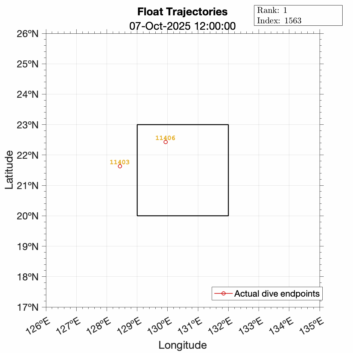
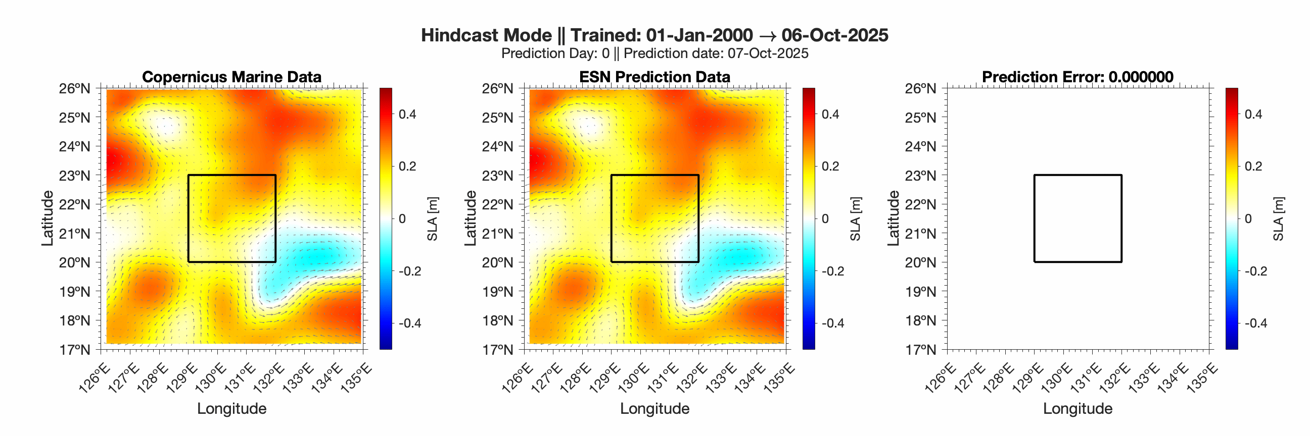
Active from February 2025 to present. This deployment was off the coast of Guam in the Philippine Sea. The outputs below are from the stochastic prediction mode. Active optimization of dive commands was performed here, under the constraint that all deep dive depths were set as 2,000 meters. This method of float control was used from 26-February-2026 until present.
12-Apr-2026 17:01:30 (UTC), Output 46
11-Apr-2026 18:21:15 (UTC), Output 45
10-Apr-2026 16:34:46 (UTC), Output 44
09-Apr-2026 14:11:30 (UTC), Output 43
08-Apr-2026 13:53:11 (UTC), Output 42
07-Apr-2026 15:34:23 (UTC), Output 41
06-Apr-2026 13:59:09 (UTC), Output 40
05-Apr-2026 14:21:05 (UTC), Output 39
04-Apr-2026 15:20:24 (UTC), Output 38
03-Apr-2026 14:10:10 (UTC), Output 37
02-Apr-2026 13:16:07 (UTC), Output 36
01-Apr-2026 14:05:32 (UTC), Output 35
31-Mar-2026 13:57:53 (UTC), Output 34
30-Mar-2026 13:49:37 (UTC), Output 33
29-Mar-2026 16:11:16 (UTC), Output 32
28-Mar-2026 16:27:53 (UTC), Output 31
27-Mar-2026 14:08:52 (UTC), Output 30
26-Mar-2026 14:01:40 (UTC), Output 29
25-Mar-2026 14:04:01 (UTC), Output 28
24-Mar-2026 13:19:51 (UTC), Output 27
23-Mar-2026 14:12:37 (UTC), Output 26
22-Mar-2026 17:51:10 (UTC), Output 25
21-Mar-2026 15:50:17 (UTC), Output 24
20-Mar-2026 13:57:16 (UTC), Output 23
19-Mar-2026 13:50:47 (UTC), Output 22
18-Mar-2026 16:12:46 (UTC), Output 21
17-Mar-2026 14:23:19 (UTC), Output 20
16-Mar-2026 14:11:18 (UTC), Output 19
15-Mar-2026 17:54:44 (UTC), Output 18
14-Mar-2026 14:16:38 (UTC), Output 17
13-Mar-2026 14:50:38 (UTC), Output 16
12-Mar-2026 14:01:21 (UTC), Output 15
11-Mar-2026 14:12:56 (UTC), Output 14
10-Mar-2026 13:35:39 (UTC), Output 13
09-Mar-2026 14:08:48 (UTC), Output 12
08-Mar-2026 15:53:45 (UTC), Output 11
07-Mar-2026 18:20:48 (UTC), Output 10
06-Mar-2026 14:59:04 (UTC), Output 9
05-Mar-2026 14:48:30 (UTC), Output 8
04-Mar-2026 15:58:57 (UTC), Output 7
03-Mar-2026 15:22:58 (UTC), Output 6
02-Mar-2026 15:14:55 (UTC), Output 5
01-Mar-2026 19:27:30 (UTC), Output 4
28-Feb-2026 16:59:51 (UTC), Output 3
27-Feb-2026 15:45:11 (UTC), Output 2
26-Feb-2026 22:01:24 (UTC), Output 1
Guam: Arcterx2 Deployment -- Deterministic Optimization FloatCast Outputs
Active from February 2025 to present. This deployment was off the coast of Guam in the Philippine Sea. The outputs below are from the deterministic prediction mode. Active optimization of dive commands was performed here, under the constraint that all deep dive depths were set as 2,000 meters. This method of float control was used from 27-November-2025 through 26-February-2026.
12-Apr-2026 16:49:46 (UTC), Output 137
11-Apr-2026 18:09:47 (UTC), Output 136
10-Apr-2026 16:11:26 (UTC), Output 135
09-Apr-2026 13:58:35 (UTC), Output 134
08-Apr-2026 13:41:58 (UTC), Output 133
07-Apr-2026 15:20:21 (UTC), Output 132
06-Apr-2026 13:48:37 (UTC), Output 131
05-Apr-2026 14:11:12 (UTC), Output 130
04-Apr-2026 15:10:02 (UTC), Output 129
03-Apr-2026 13:55:09 (UTC), Output 128
02-Apr-2026 13:03:39 (UTC), Output 127
01-Apr-2026 13:51:24 (UTC), Output 126
31-Mar-2026 13:46:39 (UTC), Output 125
30-Mar-2026 13:41:55 (UTC), Output 124
29-Mar-2026 16:04:08 (UTC), Output 123
28-Mar-2026 16:01:47 (UTC), Output 122
27-Mar-2026 13:53:43 (UTC), Output 121
26-Mar-2026 13:51:53 (UTC), Output 120
25-Mar-2026 13:53:36 (UTC), Output 119
24-Mar-2026 13:10:12 (UTC), Output 118
23-Mar-2026 14:00:42 (UTC), Output 117
22-Mar-2026 17:42:39 (UTC), Output 116
21-Mar-2026 15:42:10 (UTC), Output 115
20-Mar-2026 13:47:23 (UTC), Output 114
19-Mar-2026 13:39:14 (UTC), Output 113
18-Mar-2026 16:02:56 (UTC), Output 112
17-Mar-2026 14:12:21 (UTC), Output 111
16-Mar-2026 13:59:19 (UTC), Output 110
15-Mar-2026 17:45:46 (UTC), Output 109
14-Mar-2026 14:07:18 (UTC), Output 108
13-Mar-2026 14:39:45 (UTC), Output 107
12-Mar-2026 13:47:52 (UTC), Output 106
11-Mar-2026 13:58:47 (UTC), Output 105
10-Mar-2026 13:25:39 (UTC), Output 104
09-Mar-2026 13:57:03 (UTC), Output 103
08-Mar-2026 15:41:49 (UTC), Output 102
07-Mar-2026 18:12:37 (UTC), Output 101
06-Mar-2026 14:50:31 (UTC), Output 100
05-Mar-2026 14:37:19 (UTC), Output 99
04-Mar-2026 15:47:17 (UTC), Output 98
03-Mar-2026 14:49:22 (UTC), Output 97
02-Mar-2026 14:56:17 (UTC), Output 96
01-Mar-2026 19:13:35 (UTC), Output 95
28-Feb-2026 16:46:55 (UTC), Output 94
27-Feb-2026 15:31:34 (UTC), Output 93
26-Feb-2026 15:11:49 (UTC), Output 92
25-Feb-2026 14:55:20 (UTC), Output 91
24-Feb-2026 14:49:15 (UTC), Output 90
23-Feb-2026 15:09:32 (UTC), Output 89
22-Feb-2026 18:45:48 (UTC), Output 88
21-Feb-2026 19:14:07 (UTC), Output 87
20-Feb-2026 15:16:21 (UTC), Output 86
19-Feb-2026 14:58:04 (UTC), Output 85
18-Feb-2026 15:19:37 (UTC), Output 84
17-Feb-2026 14:48:00 (UTC), Output 83
16-Feb-2026 15:05:03 (UTC), Output 82
15-Feb-2026 16:05:08 (UTC), Output 81
14-Feb-2026 16:02:59 (UTC), Output 80
13-Feb-2026 15:05:45 (UTC), Output 79
12-Feb-2026 14:53:12 (UTC), Output 78
11-Feb-2026 14:27:20 (UTC), Output 77
10-Feb-2026 14:50:13 (UTC), Output 76
09-Feb-2026 14:56:26 (UTC), Output 75
08-Feb-2026 18:15:02 (UTC), Output 74
07-Feb-2026 17:47:20 (UTC), Output 73
06-Feb-2026 15:12:19 (UTC), Output 72
05-Feb-2026 15:18:00 (UTC), Output 71
04-Feb-2026 15:07:10 (UTC), Output 70
03-Feb-2026 15:10:44 (UTC), Output 69
02-Feb-2026 14:42:39 (UTC), Output 68
01-Feb-2026 19:04:16 (UTC), Output 67
31-Jan-2026 16:53:33 (UTC), Output 66
30-Jan-2026 17:05:55 (UTC), Output 65
29-Jan-2026 15:05:33 (UTC), Output 64
28-Jan-2026 15:02:08 (UTC), Output 63
27-Jan-2026 15:00:58 (UTC), Output 62
26-Jan-2026 15:14:52 (UTC), Output 61
25-Jan-2026 16:05:34 (UTC), Output 60
24-Jan-2026 18:29:32 (UTC), Output 59
23-Jan-2026 15:12:18 (UTC), Output 58
22-Jan-2026 15:05:39 (UTC), Output 57
21-Jan-2026 15:08:23 (UTC), Output 56
20-Jan-2026 16:18:51 (UTC), Output 55
19-Jan-2026 15:48:30 (UTC), Output 54
18-Jan-2026 19:19:36 (UTC), Output 53
17-Jan-2026 16:29:50 (UTC), Output 52
16-Jan-2026 14:41:23 (UTC), Output 51
15-Jan-2026 14:56:29 (UTC), Output 50
14-Jan-2026 15:10:29 (UTC), Output 49
13-Jan-2026 15:20:31 (UTC), Output 48
12-Jan-2026 14:54:27 (UTC), Output 47
11-Jan-2026 17:44:09 (UTC), Output 46
10-Jan-2026 15:12:16 (UTC), Output 45
09-Jan-2026 15:19:03 (UTC), Output 44
08-Jan-2026 14:54:58 (UTC), Output 43
07-Jan-2026 15:00:36 (UTC), Output 42
06-Jan-2026 15:01:51 (UTC), Output 41
05-Jan-2026 14:52:27 (UTC), Output 40
04-Jan-2026 17:32:38 (UTC), Output 39
03-Jan-2026 17:22:40 (UTC), Output 38
02-Jan-2026 15:11:04 (UTC), Output 37
01-Jan-2026 14:53:43 (UTC), Output 36
31-Dec-2025 16:56:48 (UTC), Output 35
30-Dec-2025 17:37:09 (UTC), Output 34
29-Dec-2025 16:59:36 (UTC), Output 33
28-Dec-2025 16:21:22 (UTC), Output 32
27-Dec-2025 14:17:57 (UTC), Output 31
26-Dec-2025 15:57:26 (UTC), Output 30
25-Dec-2025 14:51:54 (UTC), Output 29
24-Dec-2025 14:17:00 (UTC), Output 28
23-Dec-2025 14:12:46 (UTC), Output 27
22-Dec-2025 15:12:12 (UTC), Output 26
21-Dec-2025 18:17:08 (UTC), Output 25
20-Dec-2025 15:40:42 (UTC), Output 24
19-Dec-2025 14:55:22 (UTC), Output 23
18-Dec-2025 14:51:17 (UTC), Output 22
17-Dec-2025 14:05:51 (UTC), Output 21
16-Dec-2025 14:56:08 (UTC), Output 20
15-Dec-2025 14:48:24 (UTC), Output 19
14-Dec-2025 17:00:24 (UTC), Output 18
13-Dec-2025 15:12:33 (UTC), Output 17
12-Dec-2025 14:39:10 (UTC), Output 16
11-Dec-2025 14:48:41 (UTC), Output 15
10-Dec-2025 14:39:56 (UTC), Output 14
09-Dec-2025 14:56:26 (UTC), Output 13
08-Dec-2025 14:50:45 (UTC), Output 12
07-Dec-2025 18:37:49 (UTC), Output 11
06-Dec-2025 14:35:49 (UTC), Output 10
05-Dec-2025 14:57:58 (UTC), Output 9
04-Dec-2025 14:54:02 (UTC), Output 8
03-Dec-2025 14:49:11 (UTC), Output 7
02-Dec-2025 14:54:37 (UTC), Output 6
01-Dec-2025 14:47:50 (UTC), Output 5
30-Nov-2025 14:10:46 (UTC), Output 4
29-Nov-2025 14:09:09 (UTC), Output 3
28-Nov-2025 17:00:27 (UTC), Output 2
27-Nov-2025 19:54:54 (UTC), Output 1
Guam: Arcterx2 Deployment -- Reference Prediction FloatCast Outputs
Active from February 2025 to present. This deployment was off the coast of Guam in the Philippine Sea. Below are outputs of FloatCast where commands were fixed to 1,000 meter park depth, approximately 4-day dive duration, with deep dive depth of 2,000 meters. These commands were not applied to the floats; they are included here just as a reference.
12-Apr-2026 16:22:40 (UTC), Output 60
11-Apr-2026 17:54:43 (UTC), Output 59
10-Apr-2026 15:56:57 (UTC), Output 58
09-Apr-2026 13:38:53 (UTC), Output 57
08-Apr-2026 13:33:13 (UTC), Output 56
07-Apr-2026 15:12:48 (UTC), Output 55
06-Apr-2026 13:35:21 (UTC), Output 54
05-Apr-2026 13:52:58 (UTC), Output 53
04-Apr-2026 15:00:39 (UTC), Output 52
03-Apr-2026 13:39:16 (UTC), Output 51
02-Apr-2026 12:45:58 (UTC), Output 50
01-Apr-2026 13:40:33 (UTC), Output 49
31-Mar-2026 13:37:01 (UTC), Output 48
30-Mar-2026 13:32:35 (UTC), Output 47
29-Mar-2026 15:50:00 (UTC), Output 46
28-Mar-2026 15:46:01 (UTC), Output 45
27-Mar-2026 13:41:36 (UTC), Output 44
26-Mar-2026 13:41:26 (UTC), Output 43
25-Mar-2026 13:43:30 (UTC), Output 42
24-Mar-2026 12:59:21 (UTC), Output 41
23-Mar-2026 13:38:12 (UTC), Output 40
22-Mar-2026 17:32:36 (UTC), Output 39
21-Mar-2026 15:15:56 (UTC), Output 38
20-Mar-2026 13:37:58 (UTC), Output 37
19-Mar-2026 13:29:39 (UTC), Output 36
18-Mar-2026 15:52:51 (UTC), Output 35
17-Mar-2026 14:01:48 (UTC), Output 34
16-Mar-2026 13:47:35 (UTC), Output 33
15-Mar-2026 17:21:01 (UTC), Output 32
14-Mar-2026 13:17:22 (UTC), Output 31
13-Mar-2026 14:29:30 (UTC), Output 30
12-Mar-2026 13:36:39 (UTC), Output 29
11-Mar-2026 13:45:53 (UTC), Output 28
10-Mar-2026 13:13:45 (UTC), Output 27
09-Mar-2026 13:42:46 (UTC), Output 26
08-Mar-2026 15:16:28 (UTC), Output 25
07-Mar-2026 18:02:39 (UTC), Output 24
06-Mar-2026 14:40:31 (UTC), Output 23
05-Mar-2026 14:12:55 (UTC), Output 22
04-Mar-2026 15:33:54 (UTC), Output 21
03-Mar-2026 14:37:00 (UTC), Output 20
02-Mar-2026 14:40:30 (UTC), Output 19
01-Mar-2026 19:02:46 (UTC), Output 18
28-Feb-2026 16:21:50 (UTC), Output 17
27-Feb-2026 15:13:41 (UTC), Output 16
26-Feb-2026 14:55:59 (UTC), Output 15
25-Feb-2026 14:41:40 (UTC), Output 14
24-Feb-2026 14:36:09 (UTC), Output 13
23-Feb-2026 14:51:50 (UTC), Output 12
22-Feb-2026 18:33:53 (UTC), Output 11
21-Feb-2026 18:57:48 (UTC), Output 10
20-Feb-2026 14:42:11 (UTC), Output 9
19-Feb-2026 14:45:43 (UTC), Output 8
18-Feb-2026 14:59:18 (UTC), Output 7
17-Feb-2026 14:35:17 (UTC), Output 6
16-Feb-2026 14:53:38 (UTC), Output 5
15-Feb-2026 15:50:52 (UTC), Output 4
14-Feb-2026 15:45:12 (UTC), Output 3
13-Feb-2026 14:46:57 (UTC), Output 2
12-Feb-2026 14:41:36 (UTC), Output 1